
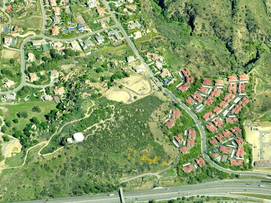
We'll start our overview of the "upper Iverson Ranch" with a look at the 1950s aerial photo above. Starting at the far left edge you'll notice a tree-line running north to south. That tree-line was the separation boundary between the Iverson Ranch to the east and the Brandeis Ranch to the west.
Just inside the tree-line on the left side of the photo you can see a wide, oak tree studded valley with lots of trails running in all directions. That valley was the most heavily used filming area on the upper ranch, and you've seen it in hundreds of Western chase scenes. On the east (or right side) of that tree-studded valley there is a rocky ridge-line that rans southwest to northeast. That ridge-line was only about 400 yards long, but it contained some of the most significant "Rock Stars" on the upper ranch. In future posts I'll show you photos and tell you about them.

Those "Rock Stars"--Medicine Rocks, Eagle Beak and the Molars, Lookout Point, Indian Head Rock (not Indianhead that's on the lower ranch), Slates, Turtle Rocks, Whale Rock and Ambush Pass--are all in the photo above.
Go back to the 1950s aerial photo at the top. Moving east from the tree studded valley there were a number of trails on adjacent ridges, and a hill in the lower left center of the photo. That hill is known as Cactus Hill. Look at the photo below and you'll spot two water tanks that were added when the ranch was developed into a gated residential community. Look carefully and you'll notice many of the old trails still exist in the same configuration.
In today's world the gated community (large estate sized homes and lots) is known as Indian Falls. It is accessed from Santa Susana Pass Road via Iverson Road going north, or from Topanga Canyon Boulavard via Poema Road going northwest. The community is not open to the public and you can't get in without an invitation.
Look back at the photo at the top of the post, and you'll see another wide valley on the far right (the trails appear almost white in the photo). That area was where a ranch set once existed. In todays world the red-roofed Summerset Village (luxury rental apartments) has replaced the ranch set which was sometimes called the Middle Ranch.
In future posts I'll show you lots of movie stills, and you'll learn about the many sets on the upper ranch. Included among them were a Stone Cabin (in a hidden valley), a Miner's Cabin (complete with mine), and the Ranch Set which included a three sided house, bungalow, bunkhouse, barn, and a couple of shacks.
Stay tuned…
Those McMansions kill me. That should all be hiking land for those of us who love the rocks and appreciate the place. We have enough McMansions at ground level. No need to spoil the hillside. Thanks for your great pix and explanations.
ReplyDeleteGreat article!!! I just watched Arizona Whirlwind on Netflix and started doing some research on the actors.. luckily, I came across your blog! I'm really looking forward to your future articles!
ReplyDelete